
Locations Database
| Address Line 1: | Picts Hill Cottage/House/Lodge |
| Address Line 2: | Bedford Road, Stevington |
| Town/City: | Turvey |
| County/State: | Bedfordshire |
| Country: | England |
| Postcode: | MK43 8BS |
| Website 1: | http://maps.google.co.uk/maps?q=MK43+8BS |
| GRO District 1: | 1837-1974 Bedford, Bedfordshire, England |
| Note 1: | Picts Hill Cottage/House/Lodge are all listed in Turvey at same postcode. |
| Occupants: | FENNELL 1866 |
| Last Updated: | 13/12/2012 11:14 |
| Address Line 1: | Copley Lane / Road |
| Address Line 2: | Copley, Lynesack & Softley |
| Town/City: | Bishop Auckland |
| County/State: | Co.Durham |
| Country: | England |
| Postcode: | DL13 5LS |
| Website 1: | http://maps.google.co.uk/maps?q=DL13+5LS |
| GRO District 1: | 1837-1938 Auckland, Co.Durham, England |
| Note 1: | Between Woodland and Butterknowle south of Hamsterley. |
| Occupants: | TATE 1841-1861 |
| Grid Reference: | NZ 08879 25326 |
| Latitude/Longitude: | 54.6230 / -1.8640 |
| Last Updated: | 13/12/2012 11:05 |
| Address Line 1: | Norwood et al |
| Address Line 2: | Evenwood |
| Town/City: | Bishop Auckland |
| County/State: | Co.Durham |
| Country: | England |
| Postcode: | DL14 9RN |
| Website 1: | http://maps.google.co.uk/maps?q=DL14+9RN |
| Website 2: | http://www.old-maps.co.uk Search = Evenwood |
| GRO District 1: | 1837-1938 Auckland, Co.Durham, England [GRO District] |
| Note 1: | GRO District is for Evenwood |
| Note 2: | Norwood Cottage/Colliery exist NW of Evenwood on Old Maps. |
| Occupants: | TATE 1817-1901 |
| Last Updated: | 13/12/2012 11:07 |
| Address Line 1: | Littleburn & Blazing Hill |
| Address Line 2: | Hamsterley |
| Town/City: | Bishop Auckland |
| County/State: | Co.Durham |
| Country: | England |
| Postcode: | DL13 3PU |
| Website 1: | http://maps.google.co.uk/maps?q=DL13+3PU |
| Website 2: | http://www.old-maps.co.uk Search = Hamsterley, Durham |
| GRO District 1: | 1837-1938 Auckland, Co.Durham, England |
| Note 1: | Blazing Hill, Littleburn, and Hamsterley Village. |
| Note 2: | Blazon Hill exists SW of Hamsterley on Old Maps. |
| Occupants: | TATE 1809 & PATTISON 1760-1787 |
| Last Updated: | 13/12/2012 11:08 |
| Address Line 1: | Railway Cottage, Etherley Bank |
| Address Line 2: | West Auckland |
| Town/City: | Bishop Auckland |
| County/State: | Co.Durham |
| Country: | England |
| Postcode: | DL14 0LQ |
| Website 1: | http://maps.google.co.uk/maps?q=DL14+0LQ |
| Website 2: | http://www.old-maps.co.uk - Search = West Auckland |
| GRO District 1: | 1837-1938 Auckland, Co.Durham, England |
| Note 1: | Railway Cottage is West of Spring Gardens on Old Maps. |
| Note 2: | In 2011: 2 Railway Cottages, Etherley Bank, High Etherley, Bishop Auckland DL14 0LQ. |
| Occupants: | TATE 1850-1851 |
| Grid Reference: | NZ 16622 26738 |
| Latitude/Longitude: | 54.6355 / -1.744 |
| Last Updated: | 13/12/2012 11:15 |
| Address Line 1: | Spring Gardens |
| Address Line 2: | West Auckland |
| Town/City: | Bishop Auckland |
| County/State: | Co.Durham |
| Country: | England |
| Postcode: | DL14 9SL |
| Website 1: | http://maps.google.co.uk/maps?q=DL14+9SL |
| Website 2: | http://www.old-maps.co.uk Search = West Auckland |
| GRO District 1: | 1837-1938 Auckland, Co.Durham, England |
| Note 1: | Spring Gardens is on old maps, and Railway Cottage, West Auckland may be nearby. |
| Occupants: | TATE 1871-1891 |
| Last Updated: | 13/12/2012 11:16 |
| Address Line 1: | Etherley & Hunter Hill |
| Address Line 2: | St.Helen Auckland |
| Town/City: | Bishop Auckland |
| County/State: | Co.Durham |
| Country: | England |
| Postcode: | DL14 0HF |
| Website 1: | http://maps.google.co.uk/maps?q=DL14+0HF |
| Website 2: | http://www.old-maps.co.uk Search = St Helen Auckland or Etherley |
| GRO District 1: | 1837-1937 Auckland, Co.Durham, England |
| Note 1: | Etherley village is 2m NW of St.Helen Auckland. |
| Note 2: | Hunter's Hill House is SW of Etherley on Old Maps. |
| Occupants: | TATE 1788-1803 |
| Last Updated: | 13/12/2012 11:17 |
| Address Line 1: | Etwall |
| Town/City: | Derby |
| County/State: | Derbyshire |
| Country: | England |
| Postcode: | DE65 6LP |
| Website 1: | http://maps.google.co.uk/maps?q=DE65+6LP |
| GRO District 1: | 1837-1936 Burton upon Trent, Derbyshire, England |
| Note 1: | WEMM family home. |
| Occupants: | WEMM 1900 |
| Last Updated: | 13/12/2012 11:07 |
| Address Line 1: | Derby Road |
| Town/City: | Willington |
| County/State: | Derbyshire |
| Country: | England |
| Postcode: | DE65 6BP |
| Website 1: | http://maps.google.co.uk/maps?q=DE65+6BP |
| Website 2: | http://www.old-maps.co.uk Search = Willington |
| GRO District 1: | 1837-1936 Burton upon Trent, Derbyshire, England |
| Note 1: | Not certain where Derby Road was in 1901 even on Old Maps. |
| Occupants: | WEMM 1901 |
| Last Updated: | 13/12/2012 11:06 |
| Address Line 1: | Sewage Works |
| Address Line 2: | Boundary Road |
| Town/City: | Willington |
| County/State: | Derbyshire |
| Country: | England |
| Postcode: | DE65 6GX |
| Website 1: | http://maps.google.co.uk/maps?q=DE65+6GX |
| Website 2: | http://www.old-maps.co.uk Search = Willington |
| GRO District 1: | 1837-1936 Burton upon Trent, Derbyshire, England |
| Note 1: | Sewage Works are NW of Willington. |
| Occupants: | WEMM 1901-1902 |
| Grid Reference: | SK 28037 29582 |
| Latitude/Longitude: | 52.863 / -1.585 |
| Last Updated: | 13/12/2012 11:16 |
| Address Line 1: | Honestone Lane |
| Town/City: | Bideford |
| County/State: | Devon |
| Country: | England |
| Postcode: | EX39 2DH |
| Website 1: | http://maps.google.co.uk/maps?q=EX39+2DH |
| Website 2: | http://www.old-maps.co.uk Search = Bideford |
| GRO District 1: | 1837-1974 Bideford, Devon, England |
| Note 1: | Honestone Lane is now Honestone Street - see Old Maps. |
| Occupants: | CUTCLIFFE 1851 |
| Last Updated: | 13/12/2012 11:10 |
| Address Line 1: | Northam |
| Town/City: | Bideford |
| County/State: | Devon |
| Country: | England |
| Postcode: | EX39 1AR |
| Website 1: | http://maps.google.co.uk/maps?q=EX39+1AR |
| GRO District 1: | 1837-1974 Bideford, Devon, England |
| Note 1: | North Devon village. |
| Occupants: | HUGHES 1840 |
| Last Updated: | 13/12/2012 11:13 |
| Address Line 1: | Potters Lane |
| Town/City: | Bideford |
| County/State: | Devon |
| Country: | England |
| Postcode: | EX39 2NW |
| Website 1: | http://maps.google.co.uk/maps?q=EX39+2NW |
| Website 2: | http://www.bidefordtown.co.uk/north-devon-pottery-scraffito-slipware-/north-devon-pottery-scraffito-slipware-bideford.html |
| GRO District 1: | 1837-1974 Bideford, Devon, England |
| Note 1: | Potters Lane is now called North Road - see Website 2 above. |
| Occupants: | CUTCLIFFE 1861 |
| Last Updated: | 13/12/2012 11:15 |
| Address Line 1: | Greenbanks, 5a Greenway Road |
| Address Line 2: | Galmpton |
| Town/City: | Brixham |
| County/State: | Devon |
| Country: | England |
| Postcode: | TQ5 0LR |
| Website 1: | http://maps.google.co.uk/maps?q=TQ5+0LR |
| Website 2: | http://www.tatewise.co.uk |
| GRO District 1: | 1968-1974 Torbay, Devon, England |
| GRO District 2: | after 1974 ? |
| Note 1: | Detached bungalow built 1983. |
| Occupants: | TATE 2003-now |
| Last Updated: | 08/12/2012 22:46 |
| Address Line 1: | Bournemouth County Court |
| Address Line 2: | Stafford Road |
| Town/City: | Bournemouth |
| County/State: | Dorset |
| Country: | England |
| Postcode: | BH1 1LA |
| Website 1: | http://maps.google.co.uk/maps?q=BH1+1LA |
| GRO District 1: | after 1974 Bournemouth, Dorset, England |
| Note 1: | In 2011 this is now the Bournemouth Magistrates/Coroners Court BH1 1LA/1LE. |
| Note 2: | Bournemouth County Court (BH1 1PN) is now in Deansleigh Road BH7 7DS. |
| Occupants: | TATE 1990-1991 |
| Last Updated: | 13/12/2012 11:03 |
| Address Line 1: | Bournemouth Crematorium |
| Address Line 2: | Strouden Avenue |
| Town/City: | Bournemouth |
| County/State: | Dorset |
| Country: | England |
| Postcode: | BH8 9HX |
| Website 1: | http://maps.google.co.uk/maps?q=BH8+9HX |
| Website 2: | http://www.bournemouth.gov.uk/PeopleLiving/Maps/CemeteriesandCrematoria/BournemouthCrematorium.aspx |
| Website 3: | http://www.millerbrosfunerals.co.uk |
| GRO District 1: | after 1974 Bournemouth, Dorset, England |
| Note 1: | 1993 Bernard TATE was cremated. |
| Note 2: | 2006 Ethel Mary TATE was cremated. |
| Occupants: | TATE 1993+2006 |
| Last Updated: | 13/12/2012 14:57 |
| Address Line 1: | 10 Orchard Mews |
| Address Line 2: | Riverdale Lane |
| Town/City: | Christchurch |
| County/State: | Dorset |
| Country: | England |
| Postcode: | BH23 1RL |
| Website 1: | http://maps.google.co.uk/maps?q=BH23+1RL |
| GRO District 1: | after 1974 Bournemouth, Dorset, England |
| Note 1: | Retirement ground floor flat built circa 1980. |
| Occupants: | TATE 1990-2006 |
| Last Updated: | 13/12/2012 10:44 |
| Address Line 1: | 60 Endfield Road |
| Town/City: | Christchurch |
| County/State: | Dorset |
| Country: | England |
| Postcode: | BH23 2HU |
| Website 1: | http://maps.google.co.uk/maps?q=BH23+2HU |
| GRO District 1: | 1932-1974 Christchurch, Hampshire, England |
| GRO District 2: | after 1974 Bournemouth, Dorset, England |
| Note 1: | Deatched bungalow built circa 1950. |
| Occupants: | TATE 1971-now |
| Last Updated: | 13/12/2012 10:55 |
| Address Line 1: | Christchurch Hospital |
| Address Line 2: | Fairmile Road |
| Town/City: | Christchurch |
| County/State: | Dorset |
| Country: | England |
| Postcode: | BH23 2JX |
| Website 1: | http://maps.google.co.uk/maps?q=BH23+2JX |
| Website 2: | http://en.wikipedia.org/wiki/Christchurch_Hospital,_Dorset |
| GRO District 1: | after 1974 Bournemouth, Dorset, England |
| GRO District 2: | after ~1995 East Dorset, Dorset, England |
| Note 1: | 1993 Bernard Tate died. |
| Note 2: | 1998 Donald Tate died. |
| Occupants: | TATE 1993 & 1998 |
| Last Updated: | 13/12/2012 11:05 |
| Address Line 1: | Christchurch Priory |
| Address Line 2: | Quay Road |
| Town/City: | Christchurch |
| County/State: | Dorset |
| Country: | England |
| Postcode: | BH23 1BU |
| Website 1: | http://maps.google.co.uk/maps?q=BH23+1BX |
| GRO District 1: | after 1974 Bournemouth, Dorset, England |
| Note 1: | 1986 Colin TATE married. |
| Note 2: | 1993 Bernard TATE buried in Garden of Rest. |
| Note 3: | 2006 Ethel Mary TATE buried in Garden of Rest. |
| Occupants: | TATE 1986-2006 |
| Last Updated: | 13/12/2012 11:05 |
| Address Line 1: | 7 Hillary Mount |
| Town/City: | Billericay |
| County/State: | Essex |
| Country: | England |
| Postcode: | CM12 9JS |
| Website 1: | http://maps.google.co.uk/maps?q=CM12+9JS |
| GRO District 1: | 1939-1974 Brentwood, Essex, England (succeeded Billericay) |
| Note 1: | TATE family home. |
| Occupants: | TATE 1967 |
| Last Updated: | 13/12/2012 10:56 |
| Address Line 1: | 3 Redgates Place |
| Address Line 2: | Springfield |
| Town/City: | Chelmsford |
| County/State: | Essex |
| Country: | England |
| Postcode: | CM2 6BG |
| Website 1: | http://maps.google.co.uk/maps?q=CM2+6BG |
| GRO District 1: | 1837-1974 Chelmsford, Essex, England |
| GRO District 2: | after 1974 ? |
| Note 1: | Detached house built 1983. |
| Occupants: | TATE 1983-1988 |
| Last Updated: | 13/12/2012 10:50 |
| Address Line 1: | 3 Torquay Road |
| Address Line 2: | Springfield |
| Town/City: | Chelmsford |
| County/State: | Essex |
| Country: | England |
| Postcode: | CM1 6NF |
| Website 1: | http://maps.google.co.uk/maps?q=CM1+6NF |
| GRO District 1: | 1837-1974 Chelmsford, Essex, England |
| Note 1: | Ground floor maisonnette built circa 1960. |
| Occupants: | TATE 1970-1974 |
| Last Updated: | 13/12/2012 10:50 |
| Address Line 1: | 39 Well Lane |
| Address Line 2: | Galleywood |
| Town/City: | Chelmsford |
| County/State: | Essex |
| Country: | England |
| Postcode: | CM2 8QZ |
| Website 1: | http://maps.google.co.uk/maps?q=CM2+8QZ |
| GRO District 1: | 1837-1974 Chelmsford, Essex, England |
| Note 1: | Semi-detached rented cottage. |
| Occupants: | TATE 1968-1970 |
| Last Updated: | 13/12/2012 10:52 |
| Address Line 1: | 7 Plymouth Road |
| Address Line 2: | Springfield |
| Town/City: | Chelmsford |
| County/State: | Essex |
| Country: | England |
| Postcode: | CM1 6JG |
| Website 1: | http://maps.google.co.uk/maps?q=CM1+6JG |
| GRO District 1: | 1837-1974 Chelmsford, Essex, England |
| Note 1: | Detached bungalow built circa 1960. |
| Occupants: | TATE 1974-1983 |
| Last Updated: | 13/12/2012 10:57 |
| Address Line 1: | Scott's, Hatfield Cottage |
| Address Line 2: | The Street, Hatfield Peverel |
| Town/City: | Chelmsford |
| County/State: | Essex |
| Country: | England |
| Postcode: | CM3 2DR |
| Website 1: | http://maps.google.co.uk/maps?q=CM3+2DR |
| GRO District 1: | 1880-1974 Braintree, Essex, England |
| GRO District 2: | after 1974 ? |
| Note 1: | Detached house originally built circa 1750. |
| Occupants: | TATE 1988-2003 |
| Last Updated: | 08/12/2012 23:29 |
| Address Line 1: | Berk Hill Cottages / Goldens |
| Address Line 2: | Netteswell / Netteswell Common |
| Town/City: | Harlow |
| County/State: | Essex |
| Country: | England |
| Postcode: | CM20 2QD |
| Website 1: | http://maps.google.co.uk/maps?q=CM20+2QD |
| Website 2: | http://www.old-maps.co.uk Search = Netteswell |
| GRO District 1: | 1837-1974 Epping, Essex, England |
| Note 1: | Old Maps 1873-1960 show Netteswell but no matching place names. |
| Occupants: | DORRINGTON 1841-1881 |
| Last Updated: | 20/12/2012 11:52 |
| Address Line 1: | 132 Park Road |
| Town/City: | Ilford |
| County/State: | Essex |
| Country: | England |
| Postcode: | IG1 1SQ |
| Website 1: | http://maps.google.co.uk/maps?q=IG1+1SQ |
| GRO District 1: | 1939-1965 Ilford, Essex, England |
| GRO District 2: | 1965-1974 Redbridge, Greater London, England |
| Note 1: | Terrace house built circa 1946. |
| Occupants: | TATE 1947-1970 |
| Last Updated: | 13/12/2012 10:46 |
| Address Line 1: | 55 Woodlands Road |
| Town/City: | Ilford |
| County/State: | Essex |
| Country: | England |
| Postcode: | IG1 1JN |
| Website 1: | http://maps.google.co.uk/maps?q=IG1+1JN |
| GRO District 1: | 1837-1939 Romford, Essex, England |
| GRO District 2: | 1939-1965 Ilford, Essex, England |
| Note 1: | DODD family home. |
| Occupants: | DODD 1909-1911 |
| Last Updated: | 13/12/2012 10:54 |
| Address Line 1: | 58 Wansford Road |
| Town/City: | Woodford Green |
| County/State: | Essex |
| Country: | England |
| Postcode: | IG8 7AA |
| Website 1: | http://maps.google.co.uk/maps?q=IG8+7AA |
| GRO District 1: | 1935-1965 Essex South Western, Essex, England |
| Note 1: | TATE family home. |
| Occupants: | TATE 1946-1947 |
| Last Updated: | 13/12/2012 10:54 |
| Address Line 1: | 130 Chandos Road |
| Address Line 2: | Stratford |
| Town/City: | London |
| County/State: | Greater London |
| Country: | England |
| Postcode: | E15 1TU |
| Website 1: | http://maps.google.co.uk/maps?q=E15+1TU |
| GRO District 1: | 1837-1965 West Ham, Essex, England |
| Note 1: | DOSS family home. |
| Occupants: | DODD 1881-1882 |
| Last Updated: | 13/12/2012 10:46 |
| Address Line 1: | 159 Major Road |
| Address Line 2: | Stratford |
| Town/City: | London |
| County/State: | Greater London |
| Country: | England |
| Postcode: | E15 1DY |
| Website 1: | http://maps.google.co.uk/maps?q=E15+1DY |
| GRO District 1: | 1837-1965 West Ham, Essex, England |
| Note 1: | DODD family home. |
| Occupants: | DODD 1891-1901 |
| Last Updated: | 13/12/2012 10:47 |
| Address Line 1: | 16a Goswell Road |
| Address Line 2: | Aldersgate / Holborn |
| Town/City: | London |
| County/State: | Greater London |
| Country: | England |
| Postcode: | EC1M 7AA |
| Website 1: | http://maps.google.co.uk/maps?q=EC1M+7AA |
| GRO District 1: | 1869-1889 Holborn, Middlesex, England |
| GRO District 2: | 1889-1915 Holborn, London, England |
| Note 1: | REYNOLDS family home & workplace. |
| Note 2: | 16-18 Goswell Road is a Costcutter Supermarket in 2011. |
| Occupants: | REYNOLDS 1909-1911 |
| Last Updated: | 13/12/2012 10:47 |
| Address Line 1: | 173 Boleyn Road |
| Address Line 2: | Upton, Forest Gate |
| Town/City: | London |
| County/State: | Greater London |
| Country: | England |
| Postcode: | E7 9QH |
| Website 1: | http://maps.google.co.uk/maps?q=E7+9QH |
| GRO District 1: | 1837-1965 West Ham, Essex, England |
| Note 1: | DODD family home. |
| Occupants: | DODD 1909-1912 |
| Last Updated: | 13/12/2012 10:48 |
| Address Line 1: | 3 Pauls Alley |
| Address Line 2: | St.Giles, Cripplegate |
| Town/City: | London |
| County/State: | Greater London |
| Country: | England |
| Postcode: | EC2Y 8DT |
| Website 1: | http://maps.google.co.uk/maps?q=EC2Y+8DT |
| Website 2: | http://london1868.com/weller31b.htm London 1868 Map |
| Website 3: | http://www.old-maps.co.uk Search = EC2Y 8DT |
| GRO District 1: | 1837-1838 Bishopsgate, Middlesex/London, England |
| GRO District 2: | 1838-1869 East London, Middlesex/London, England |
| GRO District 3: | 1870-1907 London City, Middlesex/London, England |
| Note 1: | Pauls Alley found on London 1868 Map and Old Maps 1851-1954. |
| Occupants: | REYNOLDS 1834-1865 |
| Last Updated: | 13/12/2012 10:50 |

~ 3 Pauls Alley, St.Giles, Cripplegate, London ~, 1868
| Address Line 1: | 3 Pauls Alley |
| Address Line 2: | St.Giles, Cripplegate |
| Town/City: | London |
| County/State: | Greater London |
| Country: | England |
| Postcode: | EC2Y 8DT |
| Website 1: | http://maps.google.co.uk/maps?q=EC2Y+8DT |
| Website 2: | http://london1868.com/weller31b.htm London 1868 Map |
| Website 3: | http://www.old-maps.co.uk Search = EC2Y 8DT |
| GRO District 1: | 1837-1838 Bishopsgate, Middlesex/London, England |
| GRO District 2: | 1838-1869 East London, Middlesex/London, England |
| GRO District 3: | 1870-1907 London City, Middlesex/London, England |
| Note 1: | Pauls Alley found on London 1868 Map and Old Maps 1851-1954. |
| Occupants: | REYNOLDS 1834-1865 |
| Last Updated: | 13/12/2012 10:50 |
| Address Line 1: | 38 Hall Road |
| Address Line 2: | East Ham |
| Town/City: | London |
| County/State: | Greater London |
| Country: | England |
| Postcode: | E6 2NQ |
| Website 1: | http://maps.google.co.uk/maps?q=E6+2NQ |
| Website 2: | http://maps.google.co.uk/maps?q=E6+2NG |
| GRO District 1: | 1837-1935 West Ham, Essex, England |
| GRO District 2: | 1935-1965 East Ham, Essex, England |
| GRO District 3: | 1965-1967 West Ham / East Ham, Greater London, England |
| GRO District 4: | 1968-1974 Newham, Greater London, England |
| Note 1: | FLOWER Family: 17 Hall Road, East Ham, London E6 2NG nearly opposite. |
| Note 2: | Terrace houses built circa 1900. |
| Occupants: | TATE 1912-1967 |
| Last Updated: | 13/12/2012 10:51 |
| Address Line 1: | 74 Lower Kennington Lane |
| Address Line 2: | Kennington, Lambeth |
| Town/City: | London |
| County/State: | Greater London |
| Country: | England |
| Postcode: | SE11 4HW |
| Website 1: | http://maps.google.co.uk/maps?q=SE11+4HW |
| GRO District 1: | 1889-1965 Lambeth, London, England |
| Note 1: | Somewhere between Chester Way & Renfrew Road. |
| Occupants: | FULLER 1917-1922 |
| Last Updated: | 13/12/2012 10:57 |
~ Bull Yard, Fann Street, Aldersgate, London ~, 1868
| Address Line 1: | Bull Yard / 21a Fann Street |
| Address Line 2: | Aldersgate |
| Town/City: | London |
| County/State: | Greater London |
| Country: | England |
| Postcode: | EC1Y 0RB |
| Website 1: | http://maps.google.co.uk/maps?q=EC1Y+0RB |
| Website 2: | http://london1868.com/weller31b.htm London 1868 Map |
| Website 3: | http://www.old-maps.co.uk Search = Fann Street or EC1Y 0RB |
| GRO District 1: | 1837-1838 Bishopsgate, Middlesex/London, England |
| GRO District 2: | 1838-1869 East London, Middlesex/London, England |
| GRO District 3: | 1870-1907 London City, Middlesex/London, England |
| Note 1: | Bull Yard is integral with Fann Street, which still existed in 2010. |
| Note 2: | Ward/Parish is Glasshouse Yard, which is on other side of Aldersgate Street. |
| Occupants: | REYNOLDS 1867-1901 |
| Last Updated: | 13/12/2012 11:05 |
~ 21a Fann Street, Aldersgate, London ~, 1868
| Address Line 1: | Bull Yard / 21a Fann Street |
| Address Line 2: | Aldersgate |
| Town/City: | London |
| County/State: | Greater London |
| Country: | England |
| Postcode: | EC1Y 0RB |
| Website 1: | http://maps.google.co.uk/maps?q=EC1Y+0RB |
| Website 2: | http://london1868.com/weller31b.htm London 1868 Map |
| Website 3: | http://www.old-maps.co.uk Search = Fann Street or EC1Y 0RB |
| GRO District 1: | 1837-1838 Bishopsgate, Middlesex/London, England |
| GRO District 2: | 1838-1869 East London, Middlesex/London, England |
| GRO District 3: | 1870-1907 London City, Middlesex/London, England |
| Note 1: | Bull Yard is integral with Fann Street, which still existed in 2010. |
| Note 2: | Ward/Parish is Glasshouse Yard, which is on other side of Aldersgate Street. |
| Occupants: | REYNOLDS 1867-1901 |
| Last Updated: | 13/12/2012 11:05 |
| Address Line 1: | Flat 1, Tregail |
| Address Line 2: | Mercier Road, Putney |
| Town/City: | London |
| County/State: | Greater London |
| Country: | England |
| Postcode: | SW15 2AS |
| Website 1: | http://maps.google.co.uk/maps?q=SW15+2AS |
| GRO District 1: | 1965-1974 Wandsworth, Greater London, England |
| GRO District 2: | after 1974 ? |
| Note 1: | Ground floor flat. |
| Occupants: | TATE 1995-1999 |
| Last Updated: | 13/12/2012 11:08 |
| Address Line 1: | LEB Service Centre |
| Address Line 2: | 705 Romford Road, Manor Park |
| Town/City: | London |
| County/State: | Greater London |
| Country: | England |
| Postcode: | E12 6QN |
| Website 1: | http://maps.google.co.uk/maps?q=E12+6QN |
| Website 2: | http://en.wikipedia.org/wiki/London_Electricity_Board |
| GRO District 1: | 1935-1965 East Ham, Essex, England |
| GRO District 2: | 1965-1974 Newham, Greater London, England |
| Note 1: | 19??-1948 East Ham County Borough Corporation |
| Note 2: | 1948-1990 London Electricity Board (Electricity Act 1947) |
| Note 3: | Also other Service Centres, etc |
| Occupants: | TATE 1946-1970 |
| Grid Reference: | TQ 42070 85530 |
| Last Updated: | 13/12/2012 11:10 |
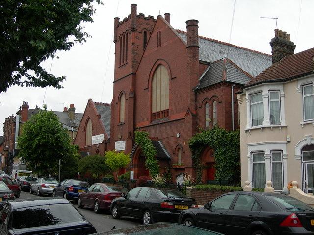
Presbyterian Church, East Avenue, London 1939-2007 © Copyright Danny Robinson and licensed for reuse under this Creative Commons Licence
| Address Line 1: | Presbyterian Church |
| Address Line 2: | next to 1 East Avenue |
| Town/City: | East Ham, London |
| County/State: | Greater London |
| Country: | England |
| Postcode: | E12 6SQ |
| Website 1: | http://maps.google.co.uk/maps?q=E12+6SQ |
| Website 2: | http://www.thetrinitycentre.org Trinity Community Centre |
| GRO District 1: | 1935-1965 East Ham, Essex, England |
| Note 1: | Now it is Trinity Community Centre - see Website. |
| Occupants: | TATE 1939 |
| Grid Reference: | TQ 42370 84396 |
| Latitude/Longitude: | 51.540513 / 0.0515255 |
| Last Updated: | 13/12/2012 10:40 |
| Address Line 1: | North Waltham |
| Address Line 2: | near Micheldever |
| Town/City: | Basingstoke |
| County/State: | Hampshire |
| Country: | England |
| Postcode: | RG25 2BH |
| Website 1: | http://maps.google.co.uk/maps?q=RG25+2BH |
| GRO District 1: | 1837-1974 Basingstoke, Hampshire, England |
| Note 1: | Village near Micheldever Station. |
| Occupants: | TATE 1911 |
| Last Updated: | 13/12/2012 11:13 |
| Address Line 1: | No.1 ~ No.24 Tate's Terrace |
| Address Line 2: | Southampton Road |
| Town/City: | Bishopstoke, Eastleigh |
| County/State: | Hampshire |
| Country: | England |
| Postcode: | SO50 9XA |
| Website 1: | http://maps.google.co.uk/maps?q=SO50+9XA |
| Website 2: | http://www.old-maps.co.uk Search = Bishopstoke |
| GRO District 1: | 1837-1927 South Stoneham, Hampshire, England |
| Note 1: | Old Maps 1869-1872 show Tate's Terrace by Bishopstoke (Eastleigh) Station. |
| Note 2: | Later Old Maps confirm it is on Southampton Road. |
| Note 3: | 1871, 1881, 1891 Census returns list Tate's Terrace in Southampton Road. |
| Note 4: | 1901, 1911 Census returns do not list Tate's Terrace in Southampton Road. |
| Note 5: | Demolished in 1960's to build a multi-storey car park and office block. |
| Occupants: | TATE 1864-1865 |
| Last Updated: | 13/12/2012 11:19 |
| Address Line 1: | 83 / 85 Wimborne Road |
| Address Line 2: | Winton |
| Town/City: | Bournemouth |
| County/State: | Hampshire |
| Country: | England |
| Postcode: | BH3 7AN |
| Website 1: | http://maps.google.co.uk/maps?q=BH3+7AN |
| GRO District 1: | 1837-1925 Christchurch, Hampshire, England for Winton |
| Note 1: | 81 & 85 still exist as Dental Surgeons, but 81a, 83, 83a, 83b, 85a appear to be flats. |
| Occupants: | NICKLEN 1891-1911 |
| Last Updated: | 13/12/2012 11:01 |
| Address Line 1: | Moordown Village |
| Town/City: | Bournemouth |
| County/State: | Hampshire |
| Country: | England |
| Postcode: | BH9 2BS |
| Website 1: | http://maps.google.co.uk/maps?q=BH9+2BS |
| Website 2: | http://www.old-maps.co.uk Search = Moordown |
| GRO District 1: | 1837-1925 Christchurch, Hampshire, England for Winton/Holdenhurst |
| Note 1: | Moordown Village is shown North of Winton on Old Maps 1871-1829. |
| Occupants: | NICKLEN 1881 |
| Last Updated: | 21/12/2012 16:16 |
| Address Line 1: | 108 Desborough Road |
| Town/City: | Eastleigh |
| County/State: | Hampshire |
| Country: | England |
| Postcode: | SO50 5NN |
| Website 1: | http://maps.google.co.uk/maps?q=SO50+5NN |
| GRO District 1: | 1837-1927 South Stoneham, Hampshire, England |
| GRO District 2: | 1927-1932 Eastleigh, Hampshire, England |
| GRO District 3: | 1932-1974 Winchester, Hampshire, England |
| Note 1: | TATE family home. |
| Occupants: | TATE 1938-1944 |
| Last Updated: | 15/12/2012 23:41 |
| Address Line 1: | 23 St.Margarets Road |
| Address Line 2: | Bishopstoke |
| Town/City: | Eastleigh |
| County/State: | Hampshire |
| Country: | England |
| Postcode: | SO50 6DG |
| Website 1: | http://maps.google.co.uk/maps?q=SO50+6DG |
| GRO District 1: | 1837-1927 Winchester, Hampshire, England |
| GRO District 2: | 1927-1932 Eastleigh, Hampshire, England |
| Note 1: | TATE family home. |
| Occupants: | TATE 1911 |
| Last Updated: | 13/12/2012 10:49 |
| Address Line 1: | 31 St.Marys Road |
| Address Line 2: | Bishopstoke |
| Town/City: | Eastleigh |
| County/State: | Hampshire |
| Country: | England |
| Postcode: | SO50 6BP |
| Website 1: | http://maps.google.co.uk/maps?q=SO50+6BP |
| GRO District 1: | 1837-1927 Winchester, Hampshire, England |
| GRO District 2: | 1927-1932 Eastleigh, Hampshire, England |
| Note 1: | TATE family home. |
| Occupants: | TATE 1911 |
| Last Updated: | 13/12/2012 10:51 |
| Address Line 1: | 65 / 285 Chamberlayne Road |
| Town/City: | Eastleigh |
| County/State: | Hampshire |
| Country: | England |
| Postcode: | SO50 5JJ / SO50 5HX |
| Website 1: | http://maps.google.co.uk/maps?q=SO50+5JJ |
| Website 2: | http://maps.google.co.uk/maps?q=SO50+5HX |
| GRO District 1: | 1837-1927 South Stoneham, Hampshire, England |
| GRO District 2: | 1927-1932 Eastleigh, Hampshire, England |
| GRO District 3: | 1932-1974 Winchester, Hampshire, England |
| Note 1: | In 2010: |
| Note 2: | 65 = Factory Road Studios (on corner with Factory Road). |
| Note 3: | 285 = Communication Workers Union, Wessex South Central Branch, Secretary. |
| Occupants: | TATE 1911-1967 |
| Last Updated: | 15/12/2012 23:43 |
| Address Line 1: | Treforest, North End Road / Leigh Road |
| Address Line 2: | Chandler's Ford |
| Town/City: | Eastleigh |
| County/State: | Hampshire |
| Country: | England |
| Postcode: | SO53 3AX |
| Website 1: | http://maps.google.co.uk/maps?q=SO53+3AX |
| Website 2: | http://www.old-maps.co.uk Search = Eastleigh |
| GRO District 1: | 1897-1974 Winchester, Hampshire, England |
| Note 1: | Treforest built circa 1900 still existed circa 1960 and appears as either of following: |
| Note 2: | circa 1929 North End Road, Chandlers Ford, Hursley, Southampton. |
| Note 3: | circa 1938 Leigh Road, Chandlers Ford, Eastleigh, Southampton from TATE, Henry 1938 Death. |
| Note 4: | Sept 1930 North End School, Leigh Road opened. |
| Note 5: | Old Maps of 1933 name western Leigh Road as North End Road and area as Northend. |
| Occupants: | TATE 1916-1938 |
| Last Updated: | 13/12/2012 11:20 |
| Address Line 1: | 2 Union Row / West End (House) / 290 |
| Address Line 2: | West Street |
| Town/City: | Fareham |
| County/State: | Hampshire |
| Country: | England |
| Postcode: | PO16 0JN |
| Website 1: | http://maps.google.co.uk/maps?q=PO16+0JN |
| GRO District 1: | 1837-1932 Fareham, Hampshire, England |
| Note 1: | West Street still existed in 2011 but Postcode is only approximate. |
| Note 2: | Old Maps 1868-1910 show West Street but no other place names. |
| Occupants: | TATE 1848-1901 |
| Last Updated: | 17/12/2012 16:41 |
| Address Line 1: | Carter's Clay Farm |
| Address Line 2: | Carter's Clay |
| Town/City: | Lockerley |
| County/State: | Hampshire |
| Country: | England |
| Postcode: | SO51 0GN |
| Website 1: | http://maps.google.co.uk/maps?q=SO51+0GN |
| GRO District 1: | 1837~1845 Romsey & Mitchelmersh, Hampshire, England |
| GRO District 2: | 1837-1932 Romsey, Hampshire, England |
| Note 1: | Postcode is of Carter's Clay Farm near centre of Carter's Clay village. |
| Occupants: | OLDEN 1841-1881 |
| Grid Reference: | SU 30677 24760 |
| Latitude/Longitude: | 51.0214 / -1.564 |
| Last Updated: | 21/12/2012 14:10 |
| Address Line 1: | Hatt Hill |
| Address Line 2: | Hatt Lane |
| Town/City: | Mottisfont |
| County/State: | Hampshire |
| Country: | England |
| Postcode: | SO51 0LH |
| Website 1: | http://maps.google.co.uk/maps?q=SO51+0LH |
| Website 2: | http://www.old-maps.co.uk Search = Mottisfont |
| GRO District 1: | 1837-1932 Romsey, Hampshire, England |
| Note 1: | TATE family home. |
| Note 2: | Old Maps 1871-1986 show Hatt Hill by Hatt Farm at west end of Hatt Lane. |
| Occupants: | TATE 1881-1891 |
| Last Updated: | 13/12/2012 11:09 |
| Address Line 1: | Mount Farm |
| Address Line 2: | Romsey Road [?] |
| Town/City: | Mottisfont |
| County/State: | Hampshire |
| Country: | England |
| Postcode: | SO51 0GR [?] |
| Website 1: | http://maps.google.co.uk/maps?q=SO51+0GR |
| Website 2: | http://www.british-history.ac.uk/report.aspx?compid=56868 |
| Website 3: | http://www.old-maps.co.uk Search = Mottisfont |
| GRO District 1: | 1837-1932 Romsey, Hampshire, England |
| GRO District 2: | 1932-1974 Romsey & Stockbridge, Hampshire, England |
| Note 1: | Several online references exist for Mount Farm and neighbouring Hyde Farm in Mottisfont/Lockerley. |
| Note 2: | Not sure this is the Mount Farm in Census as is far from Mottisfont, but existed in 2010. |
| Note 3: | Old Maps 1871-1986 show a Mount Farm here and Hyde Farm to SE on road to Romsey. |
| Occupants: | HUTCHENS 1911 |
| Last Updated: | 13/12/2012 11:11 |
| Address Line 1: | 6 Toronto Terrace |
| Address Line 2: | Highfield |
| Town/City: | Southampton |
| County/State: | Hampshire |
| Country: | England |
| Postcode: | SO17 1QB |
| Website 1: | http://maps.google.co.uk/maps?q=SO17+1QB |
| GRO District 1: | 1837-1927 South Stoneham, Hampshire, England |
| Note 1: | Postcode is approximate as address no longer exists, and not found on Old Maps. |
| Occupants: | TATE 1901 |
| Last Updated: | 13/12/2012 10:55 |
| Address Line 1: | Brownhill House |
| Address Line 2: | Lower Brownhill Road, Maybush |
| Town/City: | Southampton |
| County/State: | Hampshire |
| Country: | England |
| Postcode: | SO16 9LA |
| Website 1: | http://maps.google.co.uk/maps?q=SO16+9LA |
| GRO District 1: | 1912-1974 Southampton, Hampshire, England |
| Note 1: | Residential Home. |
| Occupants: | TATE 1971 |
| Last Updated: | 13/12/2012 11:03 |
| Address Line 1: | Christ Church of Portswood |
| Address Line 2: | Highfield Lane |
| Town/City: | Southampton |
| County/State: | Hampshire |
| Country: | England |
| Postcode: | SO17 1RL |
| Website 1: | http://maps.google.co.uk/maps?q=SO17+1RL |
| Website 2: | http://www.britishlistedbuildings.co.uk/en-135827-christ-church-portswood-southampton |
| GRO District 1: | 1837-1927 South Stoneham, Hampshire, England |
| Note 1: | Website 2: Parish Church of Portswood, originally 1846, extended 1855, 1873 & 1915. |
| Occupants: | TATE 1901 |
| Grid Reference: | SU4259914648 |
| Latitude/Longitude: | 50.9297 / -1.3952 |
| Last Updated: | 13/12/2012 11:14 |
| Address Line 1: | ? |
| Address Line 2: | West Dean |
| Town/City: | Salisbury |
| County/State: | Hampshire/Wiltshire |
| Country: | England |
| Postcode: | SP5 1JF |
| Website 1: | http://maps.google.co.uk/maps?q=SP5+1JF |
| GRO District 1: | 1837-1932 Stockbridge, Hampshire, England |
| GRO District 2: | 1932-1974 Romsey & Stockbridge, Hampshire, England |
| Note 1: | TATE family home. |
| Occupants: | TATE 1874-1878 |
| Last Updated: | 13/12/2012 11:20 |
| Address Line 1: | 92 Lemsford Court |
| Town/City: | Borehamwood |
| County/State: | Hertfordshire |
| Country: | England |
| Postcode: | WD6 2LG |
| Website 1: | http://maps.google.co.uk/maps?q=WD6+2LG |
| GRO District 1: | 1965-1974 Elstree & Potters Bar, Hertfordshire, England |
| GRO District 2: | 1965-1974 Barnet / Hendon, Greater London, England |
| GRO District 3: | after 1974 ? |
| Note 1: | TATE family home. |
| Occupants: | TATE 1981-20?? |
| Last Updated: | 13/12/2012 11:02 |
| Address Line 1: | 3 Marconi Way |
| Town/City: | St.Albans |
| County/State: | Hertfordshire |
| Country: | England |
| Postcode: | AL4 0JG |
| Website 1: | http://maps.google.co.uk/maps?q=AL4+0JG |
| GRO District 1: | 1837-1974 St.Albans, Hertfordshire, England |
| GRO District 2: | after 1974 ? |
| Note 1: | Detached house built in 2000 on old Marconi Company site. |
| Occupants: | STEVENS 2000-2006 |
| Last Updated: | 13/12/2012 10:50 |
| Address Line 1: | Kathleen Rutland Home |
| Address Line 2: | 117 Hinckley Road |
| Town/City: | Leicester Forest East |
| County/State: | Leicestershire |
| Country: | England |
| Postcode: | LE3 3PF |
| Website 1: | http://maps.google.co.uk/maps?q=LE3+3PF |
| Website 2: | http://www.vistablind.org.uk/about-us/services/residential-care-homes/ |
| GRO District 1: | after 1974 Leicestershire, Leicestershire, England |
| Note 1: | Vista's Kathleen Rutland Home for the visually impaired still existed in 2011. |
| Occupants: | PORTER 2003 |
| Last Updated: | 12/12/2012 22:08 |
| Address Line 1: | Nether Broughton |
| Town/City: | Melton Mowbray |
| County/State: | Leicestershire |
| Country: | England |
| Postcode: | LE14 3HB |
| Website 1: | http://maps.google.co.uk/maps?q=LE14+3HB |
| GRO District 1: | 1837-1974 Melton Mowbray, Leicestershire, England |
| Note 1: | PORTER family home. |
| Occupants: | PORTER 1902 |
| Last Updated: | 12/12/2012 22:08 |
| Address Line 1: | 17 Reedsfield Road |
| Town/City: | Ashford |
| County/State: | Middlesex |
| Country: | England |
| Postcode: | TW15 2HE |
| Website 1: | http://maps.google.co.uk/maps?q=TW15+2HE |
| GRO District 1: | 1965-1974 Surrey Northern, Surrey, England |
| Note 1: | TATE family home. |
| Occupants: | TATE 1966-1973 |
| Last Updated: | 13/12/2012 10:47 |
| Address Line 1: | 317 Feltham Hill Road |
| Town/City: | Ashford |
| County/State: | Middlesex |
| Country: | England |
| Postcode: | TW15 1LP |
| Website 1: | http://maps.google.co.uk/maps?q=TW15+1LP |
| GRO District 1: | 1965-1974 Surrey Northern, Surrey, England |
| Note 1: | TATE family home. |
| Occupants: | TATE 1973 |
| Last Updated: | 13/12/2012 10:51 |
| Address Line 1: | 14 Longmead Road |
| Town/City: | Hayes |
| County/State: | Middlesex |
| Country: | England |
| Postcode: | UB3 2HA |
| Website 1: | http://maps.google.co.uk/maps?q=UB3+2HA |
| GRO District 1: | 1837-1965 Uxbridge, Middlesex, England |
| Note 1: | BRYAN family home. |
| Occupants: | BRYAN 1925 |
| Last Updated: | 13/12/2012 10:46 |
| Address Line 1: | 42 Durdans Road |
| Town/City: | Southall |
| County/State: | Middlesex |
| Country: | England |
| Postcode: | UB1 2RT |
| Website 1: | http://maps.google.co.uk/maps?q=UB1+2RT |
| GRO District 1: | 1837-1947 Uxbridge, Middlesex, England |
| GRO District 2: | 1947-1965 Ealing, Middlesex, England |
| Note 1: | FULLER family home for more than 10 years. |
| Occupants: | FULLER 1936-1949 |
| Last Updated: | 13/12/2012 10:52 |
| Address Line 1: | Holy Trinity Church |
| Address Line 2: | Park View Road, off Uxbridge Road |
| Town/City: | Southall |
| County/State: | Middlesex |
| Country: | England |
| Postcode: | UB1 3HJ |
| Website 1: | http://maps.google.co.uk/maps?q=UB1+3HJ |
| GRO District 1: | 1837-1947 Uxbridge, Middlesex, England |
| GRO District 2: | 1947-1965 Ealing, Middlesex, England |
| Note 1: | All the children of Edward & Edith FULLER married at Holy Trinity Church, Southall 1939-1949. |
| Occupants: | FULLER 1939-1949 |
| Last Updated: | 13/12/2012 11:09 |
| Address Line 1: | 17 Station Road |
| Town/City: | West Drayton |
| County/State: | Middlesex |
| Country: | England |
| Postcode: | UB7 7BT |
| Website 1: | http://maps.google.co.uk/maps?q=UB7+7BT |
| GRO District 1: | 1837-1949 Uxbridge, Middlesex, England |
| Note 1: | Now it is West Drayton Post Office. |
| Occupants: | FULLER 1927 |
| Grid Reference: | TQ 062 800 |
| Latitude/Longitude: | 51:30:34N (51.50944) / 0:28:12W (-0.46993) |
| Last Updated: | 13/12/2012 10:48 |
| Address Line 1: | 6 Cleveland Road |
| Address Line 2: | Hillingdon |
| Town/City: | West Uxbridge |
| County/State: | Middlesex |
| Country: | England |
| Postcode: | UB8 2DW |
| Website 1: | http://maps.google.co.uk/maps?q=UB8+2DW |
| GRO District 1: | 1837-1965 Uxbridge, Middlesex, England |
| Note 1: | Muriel BRYAN birthplace, different from family home. |
| Occupants: | BRYAN 1925 |
| Last Updated: | 13/12/2012 10:54 |
| Address Line 1: | 8th King's Royal Irish Hussars |
| Address Line 2: | Cavalry Barracks, Barrack St, Thorpe |
| Town/City: | Norwich |
| County/State: | Norfolk |
| Country: | England |
| Postcode: | NR3 1TT |
| Website 1: | http://maps.google.co.uk/maps?q=NR3+1TT |
| Website 2: | http://www.old-maps.co.uk Search = Norwich |
| GRO District 1: | 1837-1974 Norwich, Norfolk, England |
| Note 1: | Old Maps 1887-1971 show Cavalry (Nelson) Barracks on Barrack Street. |
| Occupants: | FENNELL 1891 |
| Last Updated: | 13/12/2012 11:02 |
| Address Line 1: | 11 Beehive Street |
| Town/City: | Retford |
| County/State: | Nottinghamshire |
| Country: | England |
| Postcode: | DN22 6JE |
| Website 1: | http://maps.google.co.uk/maps?q=DN22+6JE |
| GRO District 1: | 1837-1974 East Retford, Nottinghamshire, England |
| Note 1: | PORTER family home. |
| Occupants: | PORTER 1966 |
| Last Updated: | 13/12/2012 10:45 |
| Address Line 1: | 30 Factory Street |
| Address Line 2: | Neithrop |
| Town/City: | Banbury |
| County/State: | Oxfordshire |
| Country: | England |
| Postcode: | OX16 8UE |
| Website 1: | http://maps.google.co.uk/maps?q=OX16+8UE |
| Website 2: | http://www.old-maps.co.uk Search = Banbury |
| GRO District 1: | 1837-1974 Banbury, Oxfordshire, England |
| Note 1: | Factory Street no longer exists, but ran EW just North of Market Place. |
| Note 2: | Old Maps 1882-1955 show Factory Street crossing Castle Street and Neithrop to West. |
| Occupants: | FENNELL 1881 |
| Grid Reference: | SP 43957 40577 |
| Latitude/Longitude: | 52.061832 / -1.3602405 |
| Last Updated: | 13/12/2012 10:51 |
| Address Line 1: | 8 / 39&40 / 54 / 534 |
| Address Line 2: | Broad Street |
| Town/City: | Banbury |
| County/State: | Oxfordshire |
| Country: | England |
| Postcode: | OX16 5BN / OX16 5BX / OX16 5BL |
| Website 1: | http://maps.google.co.uk/maps?q=OX16+5BN |
| Website 2: | http://maps.google.co.uk/maps?q=OX16+5BX |
| Website 3: | http://maps.google.co.uk/maps?q=OX16+5BL |
| GRO District 1: | 1837-1974 Banbury, Oxfordshire, England |
| Note 1: | Several family homes all in the same street. |
| Occupants: | CUTCLIFFE 1871-1911 |
| Last Updated: | 13/12/2012 11:00 |
| Address Line 2: | Grove Place |
| Town/City: | Banbury |
| County/State: | Oxfordshire |
| Country: | England |
| Postcode: | OX16 5BY |
| Website 1: | http://maps.google.co.uk/maps?q=OX16+5BY |
| GRO District 1: | 1837-1974 Banbury, Oxfordshire, England |
| Note 1: | Assumed to be what is now Grove Street off Broad Street where they resided later. |
| Occupants: | CUTCLIFFE 1871 |
| Last Updated: | 13/12/2012 11:08 |
| Address Line 1: | 118 Princess Street |
| Address Line 2: | Horninglow |
| Town/City: | Burton upon Trent |
| County/State:</ |