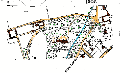
Area Plan showing Bure Homage in 1937
In the 18th century, there was a Bure Farmhouse, being a thatched farmhouse owned by Stephen Pack, Yeoman of Bure, owned by his family for several centuries. He died in 1786 and the house was then bought by Hon. General Sir Charles Stuart (1753-1801), fifth son and heir of John, third earl of Bute (1713 - 1792, Prime minister in 1762). This General Charles Stuart lived at 'High cliff' (the original Highcliffe castle) which was built by the third Earl of Bute in 1773, and Bure farm extended the estate. However, Charles Stuart was a career soldier and did not have the time or resources to maintain High cliff. Most of the estate was sold. High cliff itself was demolished when threatened by cliff erosion. His son, also Charles Stuart (1779-1845), was a successful diplomat who was Ambassador in Paris at the time of the birth of his daughters (later he become the British Ambassador to the court of Czar Nicholas I). He was given the title Lord Stuart de Rothesay. He rebuilt Bure farmhouse as Bure Homage and lived there with his wife, Elizabeth, and two daughters - Charlotte (who became Lady Canning) and Louisa (who later became the Marchioness of Waterford when she married Henry Beresford in 1842).
Area Plan showing Bure Homage in 1937
| Bure Homage was surrounded by the Bure Homage Estate with its avenue running down to the sea at Friars Cliff. This was originally lined with copper beech trees. There was an 'ice house' located next to this avenue immediately to the southwest of 'The Gables' in Bure Lane. Charles Stuart brought several Monteray Pines from France and planted them along the cliff top, as can be seen today (The trees with very rough bark are the Monteray pines. Their root system is useful for binding the cliff top, prevention erosion). Bure Homage was situated in the area which is now called Bure Homage gardens, and accessed via the lodge which is still to be seen opposite the Waterford Hotel. | 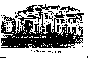 Bure Homage |
 Bure Homage |
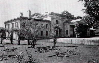
Charles then bought back the land at Highcliffe and built the 'new' Highcliffe Castle in the early 1830's which he then occupied. In 1837, Bure Homage was sold to Sophie Dawes (the daughter of an Isle of Wight fisherman/smuggler, who married the French aristocrat Baron de Feucheres). She refurbished the house adding the French style Corinthian columns. However, she became ill and died in 1840. In the mid 1850's, it was sold to Mortimer Ricardo, Esq whose ancestors had come to England from Spain to escape the Spanish Inquisition. At this time, the estate consisted of some 82 acres. Mortimer died in 1876 and his son Francis Ricardo became the owner. |
However, the Bure Homage household was in decline and in 1938, the furniture and effects of Bure Homage were auctioned in a three day sale and in 1939, the house and estate were offered for sale by Frank Ricardo and his sister Katherine Ricardo, and bought by William and Elizabeth MacKeen. The manor house and that part of the surrounding ground which became the wartime airfield was requisitioned by the Ministry of Supply. During the war it was occupied as an Officers' Mess of the American Air force, associated with the war time airfield which was extended with a grass runway. In 1945, Bure Homage was used as a barracks for members of the Royal Corps of Signals attached to S.R.D.E. but suffered considerable deterioration. The house was demolished in February 1957 by MOD and replaced by housing.
The remainder of the Bure Homage estate (the land between Bure Homage and Avon Beach and Friars Cliff) was split into many plots and sold by William Boulton in 1953.
 Behind the wood is Fisher's field, bordering Somerford Road. |
During the 1920s,
the area which is now the Airfield Industrial Estate was part of
Mudeford Farm, owned by Mr. Burry. In June 1926 "Burrys Field" was used
by Surrey Flying Service. The field to the east of that original
airfield was part of Somerford Grange Estate
and was used by Mr. Fisher for air pleasure flights and an 'Air Circus'
until 1933. This was known as Fisher's Field or Somerford Bridge, which
later became part of the Airspeed factory which later amalgamated with
DeHavilland. These two fields became BOURNEMOUTH AERODROME with
scheduled services and a flying club. The Airspeed factory was later
built on the east end of site in Somerford Road. |
During the 1939-1945 war, the area between the original airfields and Bure Homage, was requisitioned by MOD for use as a D day airfield in 1944. This had a grass runway.
In 1954 the grass runway was converted to a hard runway by the Military Engineering Experimental Establishment. Although flying ceased officially in 1964, the wartime runway was used in the sixties as an airfield for light aircraft and gliders (with a winch tow). In 1972 the area was sold for more housing and the change to the road layout, the road crossing the area of the old runway still being called 'The Runway'.
|
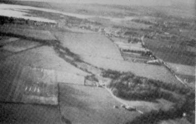
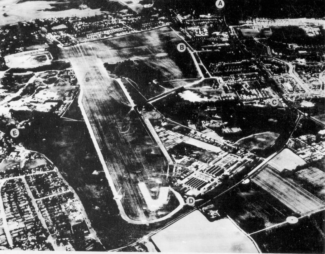
View taken around 1970 showing SRDE (now BAe) site with runway and Isle of Wight in the background |
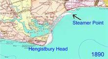
This photograph shows the hard runway just before it was sold. The photo also shows the white Radome on the SRDE ground on the cliff top at Steamer Point. This Radome dates from 1965 and housed a 40 ft diameter dish which was used to track both British and foreign satellites. It was later used as a test station for the first British Skynet military communications satellite system, later groundstations being in Cyprus and Singapore. The location was called Steamer Point because Charles Stuart (Lord Rothesay), when he was having Highcliffe Castle rebuilt, brought an old steamer which was run aground on the beach here and used to house some of the builders. |
|
Stone used for the building of Highcliffe Castle
came from the Benedictine
Abbey of St Peter at Jumieges, and the Grande Maision des Andelys, a
gothic Manor House in Normandy, and was brought across from France by
12 barges which were unloaded at Steamer Point (previously known as
Lord Bute's Gap). The 'point' has since been eroded by the sea; the
last remnants disappearing in November 1954 when the fresh water lagoon
at the base of the cliff was lost to the sea during a storm which also
washed away or destroyed around 100 beach huts. This prompted the
building of the present sea defences and, since then, beach huts have
been taken down and stored in a safe location during the winters. The
huts were left erected in 2014 and they were again destroyed by a
winter storm. |
 |
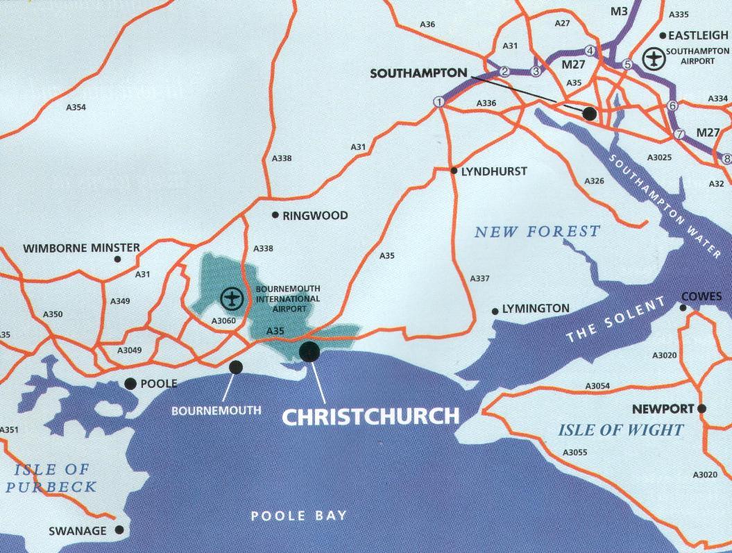
Prior to 1974, the area was part of the county of Hampshire which extended westward to include Bournemouth (but not Poole) but in 1974 the boundaries were changed such that the area is now the eastern extremity of Dorset.
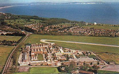
The land above 'Steamer Point' was
used by SRDE for telecommunications purposes and had a radome housing a
satellite tracking station. When SRDE moved out, the 'Steamer
Point' property was sold for Housing, car park and the Coast Guard
station, the woodland being preserved for recreation.
For the history of Somerford Estate see Somerford.htm
For the history of the area around the BAE site, click here
For maps showing the changes through the years, click here
For an aerial view of the area, click here.
For a route map of the area click here
For the SRDE website, click here and for the SRDE history, click here
For more information about Christchurch Airfield, click here.
For other historic information about
the area click here
For a history of Highcliffe, click here
(some of the early history and drawings are taken from a guide 'Bure Homage, Mudeford' written by Olive Samuel in 1985, 'Christchurch Airfield (40 Years of Flying)' by Allen White and 'Christchurch Pictorial History' by Christine Taylor)
Barrie Wells
Generated 22nd June 1998
updated 4th June 2006
For comments and/or disagreements mail me