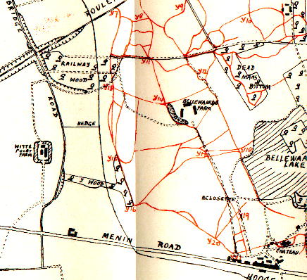
Map of the Area Near the Village of Hooge (East of Ieper), June 1915 - North is at the top
Witte Poort Farm exists on the site marked today and the ground remains farm land
Railway Wood still occupies much the same area on the map but Y Wood no longer exists.The railway is now a road.
The track leading South from the eastern end of Railway Wood still exists and runs across the top of Bellewaarde Ridge towards the Cross of Remembrance at the RE Grave. Bellewaarde Farm is now in woodland which occupies the southern part of the ridge top. 'Hooge' means 'high' in Flemish/Dutch
This map is taken extracted from 'The Liverpool Scottish 1900-1919" by Major (later Lt Colonel) A.M McGilchrist published by Henry Young & Sons, Liverpool, 1930. The author was an officer with The Liverpool Scottish during the First World War and was still serving at the time of writing.